Related news
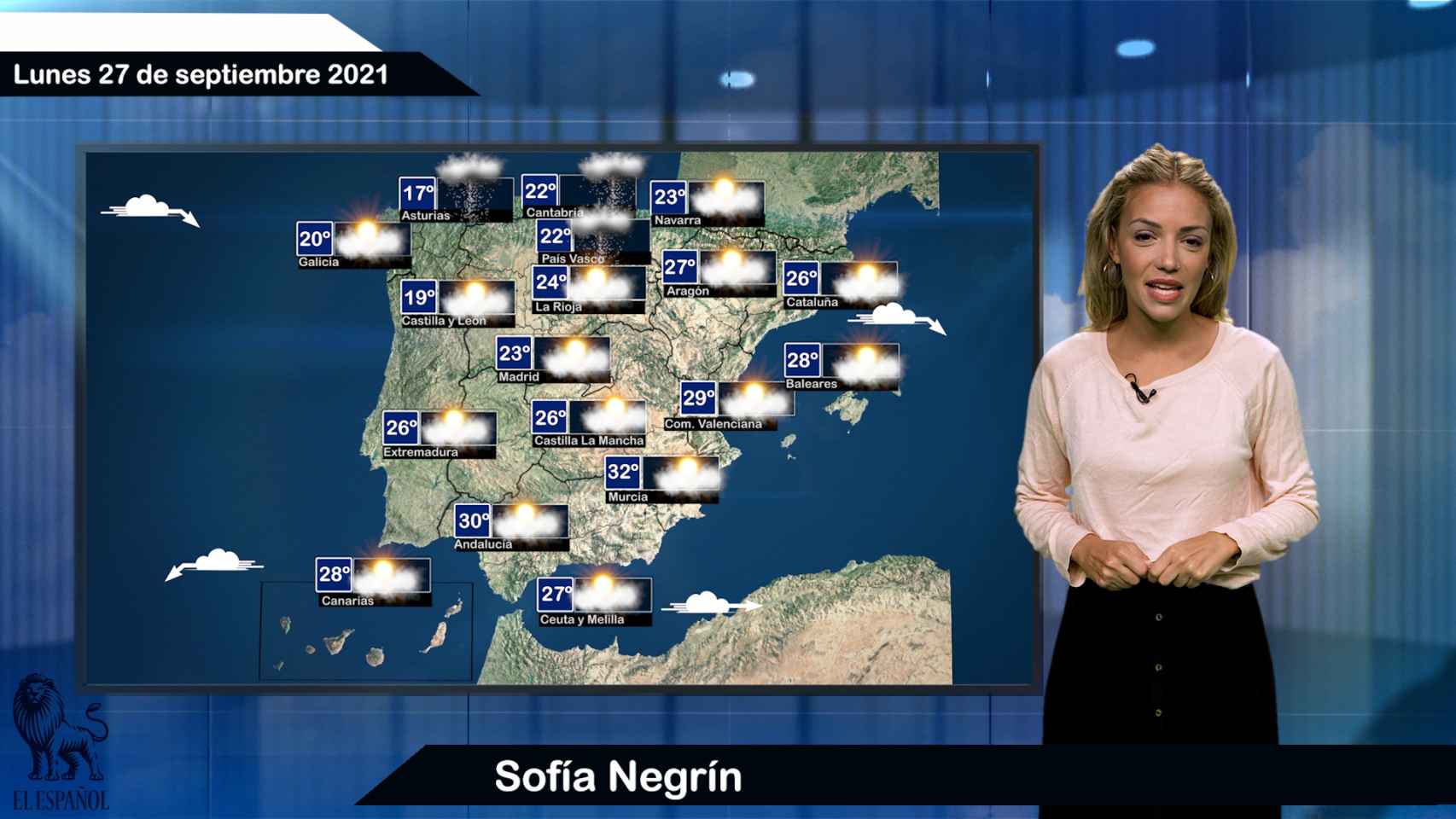
The State Meteorological Agency (Aemet) foresees for tomorrow, Monday, the arrival of an atlantic front – not very active –, which will leave in Galicia and the entire Cantabrian area rains and showers, and little cloud in the rest of the Peninsula and in the Balearic Islands.
Evolutionary cloudiness is expected with a low probability of precipitation in the north of Castilla y León, around the Pyrenees and northeast of Catalonia, tending to remit at the end in all areas; in the Canaries, cloudy or with cloudy intervals, more abundant on islands of greater relief.
Daytime temperatures will drop in Galicia and the Cantabrian area, and, in general, they will rise in the rest of the country, more pronounced in the interior of the peninsula and in the middle of the Canary Islands, with values around 34 degrees in the interior of Gran Canaria; the minimum ones go up, except in Galicia and the Mediterranean area, where they will go down.
Monday, September 27
The winds will blow from the southwest, rolling to the northwest in Galicia and the Cantabrian area with strong or very strong gusts in the early hours, from the northwest in the Ebro valley, Ampurdán and west of Andalusia, west in the Strait, and trade winds with strong gusts in the Canaries .
Prediction by autonomous communities:
GALICIA: weak rains and showers, less frequent in the southeast, decreasing in the afternoon at cloudy intervals and the precipitation remitting. Falling temperatures, or the maximums unchanged in the western third. Wind from the southwest rolling north and northwest, with strong intervals at the beginning on the north and northwest coast, without ruling out some very strong gusts of short duration.
PRINCIPALITY OF ASTURIAS: rains and showers that will move from west to east, remitting at the end of the day. Minimum temperatures slightly ascent or slightly lower in the extreme west, and maximum temperatures in descent, locally noticeable in parts of the interior. Wind from the southwest, rolling northwest in the morning, which will be weak in the interior, without ruling out some episodes of very strong, short-lived gusts at dawn on the western coast.
CANTABRIA: slightly cloudy in the first hours, soon increasing to cloudy or covered, with light rains and showers, less frequent and intense in the extreme south. Minimum temperatures rising in the western third and unchanged in the rest; declining highs, locally notable in the western interior. Wind from the southwest loose turning at dawn to the west and northwest and temporarily increasing in intensity on the coast, decreasing in the afternoon to a variable loose.
BASQUE COUNTRY: slightly cloudy in the first hours, soon increasing to cloudy or overcast, with weak rains and scattered showers, which are not expected in the southern half of Álava and which will subside at night. Minimum temperatures unchanged or with some slight ascents; maximum decreasing, except in the south and northeast coast, where they change little. South and southwest wind weak, more intense on the coast, turning at noon to north and weak on the coast.
CASTILLA Y LEÓN: in the mountainous north-west and north, with a probability of weak rainfall, eventually remitting to the west, and cloudy or cloudy intervals in the rest. Low morning cloudiness that can give rise to mist and fog. Minimum temperatures without significant changes and maximum temperatures in decrease in the extreme north and without changes or in slight ascent in the rest. Winds from the southwest to the west, tending to the north at the end.
COMMUNITY FORAL DE NAVARRA: intervals of high clouds, increasing in the northwest and the Pyrenees under cover, with probable light rains and scattered showers in the afternoon. Minimum temperatures with few changes; maximum in slight ascent in the eastern half and without changes or in slight descent in the rest. Loose wind from the south and southeast tending to the north and northwest and temporarily increasing in the south and center.
LA RIOJA: cloudy intervals increasing to cloudy. Temperatures unchanged or slightly rising. South winds tending to the north and northwest, loose.
ARAGÓN: little cloudy with intervals of high clouds. In the afternoon, retention cloudiness in the northern slope of the Pyrenees with probable weak precipitations in the divide. Minimum temperatures without changes and maximum temperatures on the rise. Loose west wind, tending in the Ebro valley to the northwest, loose to moderate.
CATALONIA: little cloudy with intervals of high clouds. In the afternoon, retention cloudiness on the northern slope of the Pyrenees with probable weak rainfall, and daytime cloudiness in the Girona Pyrenees with a low probability of isolated showers. Minimum temperatures unchanged; highs slightly ascent indoors. Loose variable wind with breezes in the afternoon on the coast, tending to a moderate north in the Ampurdán in the late hours.
EXTREMADURA: little cloudy with intervals of high clouds. Scattered morning mists and fog banks are not ruled out. Temperatures unchanged or slightly rising. Loose winds, predominantly west and northwest.
COMMUNITY OF MADRID: intervals of high clouds. Minimum temperatures slightly rising in the southeast and unchanged in the rest; highs in slight ascent. Variable loose wind, with a predominance of the west and southwest from noon.
CASTILLA-LA MANCHA: intervals of high clouds. Temperatures unchanged or slightly rising, somewhat more pronounced in the highs in the east. Variable loose wind with a predominance of the west from noon.
VALENCIAN COMMUNITY: little cloudy with intervals of high clouds. Minimum temperatures unchanged or slightly decreasing and maximum temperatures with local ascents. Variable light wind with sea breezes in the afternoon.
REGION OF MURCIA: intervals of high clouds. Minimum temperatures decreasing on the coast and with slight changes in the interior; highs unchanged on the coastline and on the rise inland. Loose variable winds with breezes.
ILLES BALEARS: intervals of high clouds. Mists and the possibility of morning fog banks. Nighttime decreasing and daytime temperatures with little change. Light wind and coastal breezes.
ANDALUSIA: intervals of high clouds. In the western third intervals of low clouds and morning fogs are expected, with probable fogs. Temperatures unchanged or rising. Loose westerly winds, increasing on the coast in the afternoon.
CANARY ISLANDS: on the northern coasts of Lanzarote and on the islands of greater relief, cloudy intervals, with slightly cloudy skies prevailing in central hours. In the rest, clear with some interval of average cloudiness in the western islands. Chance of light haze at high levels. Temperatures in slight to moderate ascent, which could become noticeable in the midlands and peaks. Northeast wind, more intense on the northwest and southeast slopes of the islands of greater relief, mainly in the second half of the day. In high areas, wind from southwest to west is light to moderate.
Follow the topics that interest you
Reference-www.elespanol.com