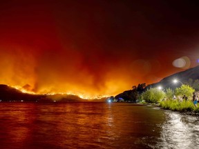
The British Columbia government has announced an interactive emergency preparedness planner to help residents prepare for the worst.

Article content
Wildfire season in British Columbia has already begun, but many residents are likely unprepared for a wildfire or other weather-related emergency.
The British Columbia government announced an interactive emergency-ready planner Thursday to help people create an emergency and evacuation plan for their families. There are also updates to the BC Wildfire Service app and updates to the Drought Information Portal with the latest drought levels and watershed conditions.
Advertisement 2
Article content
Article content
“Being prepared and feeling prepared starts with having a plan. We encourage everyone to make an emergency and evacuation plan, and the new tools launched today make planning easier and will help people stay safe,” said Bowinn Ma, Minister of Emergency Management and Climate Preparedness.
Here are some things to do before the season heats up:
Check out BC’s new emergency prepared planner
The Emergency Ready Planner is an interactive online tool to help people create a personalized emergency and evacuation plan.
The planner helps people identify emergency meeting locations, list important contacts, medical and insurance information, recommend emergency kit supplies and grab-and-go bags, and provide tips for protecting homes from wildfires.
Start at blog.gov.bc.ca.
Get familiar with the BC Wildfire app
The wildfire dashboard now has more features, including a provincial status report and easier access to fire ban information. People can submit fire reports when they are out of range of cell service. The application is available on the Apple Store and Google Play.
Article content
Advertisement 3
Article content
To learn more about BC Wildfire Service and get the app, visit: https://www2.gov.bc.ca/gov/content/safety/wildfire-status
Add the drought information portal to your favorites
The Drought Information Portal helps communities, farmers and businesses understand how drought could affect their region so they can prepare and take action. The portal provides current and historical drought levels, watershed conditions, and other precipitation, snowpack, and groundwater data by geographic region.
According to the government, the new portal has been updated to make it easier to use on all platforms.
It will be updated weekly and will provide information on how to prepare for and respond to drought, understand provincial drought conditions, and regulatory actions that are underway.
To view the updated drought website, visit: https://www.gov.bc.ca/drought
See a demo
To view the Emergency Prepared Planner, Drought Information Portal and digital demo of the BC Wildfire Service app, check out the government’s YouTube page at https://www.youtube.com/watch?v=5K2by3RWWQE
Advertisement 4
Article content
Stay up to date on evacuations and emergency alerts
To receive emergency and evacuation alerts, visit emergencyinfobc.gov.bc.ca or follow Emergency Info BC on social media at twitter.com/EmergencyInfoBC
Take note of your nearest cooling center
To view an interactive map of cooling centers and hot weather resources in BC, visit: https://governmentofbc.maps.arcgis.com/apps/webappviewer/index.html?id=950b4eec577a4dc5b298a61adab41c06
Recommended by Editorial
-

Rivers recede as British Columbia faces prospect of ‘uncharted territory’ for drought
-

Vaughn Palmer: After years of passing the buck to NDP, auditor general delves into Lytton rebuild failure
Article content


