Article content
Did you enjoy the almost summer-like conditions in Windsor-Essex last weekend?
Article content
Don’t put away your jackets and scarves just yet. Environment Canada’s weather observers are predicting a return to single-digit temperatures for our region on Wednesday.
As of Monday, the temperature low predicted for Windsor-Essex on Wednesday, April 27, is -1 C.
That’s a staggering 28-degree difference from the 27.3 C high that we enjoyed on Sunday.
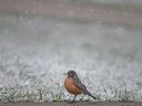
There’s even a 30 per cent chance of snow flurries on Wednesday, with the predicted temperature high only reaching 6 C.
The rest of the week doesn’t seem much better. There’s a high chance of rain on Tuesday, possibly turning into snow by the evening, and nighttime lows throughout the week are expected to hover around 0 C.
-

Photos: Snowy conditions prompts weather advisory for Windsor-Essex
-
No snowstorm for the history books in Windsor-Essex
-
Photos: Unexpected snowfall in Windsor’s Ojibway Park, April 2021


As dramatic as this spring’s turns have been, Windsor-Essex has seen table-turning weather extremes during April before.
The coldest April 27 in Windsor-Essex records was in 1971, when thermometers sank to -1.7 C.
The hottest April 27 in Windsor-Essex records was in 2009, when outside air temperatures climbed to a tropical 29.3 C.
April 27 in Windsor-Essex has been seriously wet (31.2 millimetres of rain fell here on that date in 1966) — but it has never been particularly snowy. The snowiest April 27 in Windsor-Essex history only saw 0.2 centimeters of snow (in 2004).
The average high this time of year in our region is 16.2°C, while the average low is 5.3 C.