David Phillips, senior climatologist at Environment and Climate Change Canada, said Saturday’s storm conditions were different from a system that breeds tornados, with winds all in a straight line, not rotating.
All signs were pointing to thunderstorms in the Ottawa region on Saturday, but even veteran forecasters didn’t foresee the hurricane-strength gusts or the vast area the storm would cover.
2
David Phillips, senior climatologist at Environment and Climate Change Canada, was watching conditions build from his home in Orillia.
“On Friday it was looking like it was going to be a tumultuous and active day,” a mix of cool and hot air with the risk of thunderstorms, he said.
“All day (Saturday) I couldn’t get over the fact that the temperature in Ottawa was 30 degrees and the humidex was 38. There has never been a more sultry day in Ottawa this year.
“What is weather? It’s when warm air dukes it out with cold air. That’s essentially where you get violent weather.” And in springtime, “the warm air is never too far from cold air.”
-
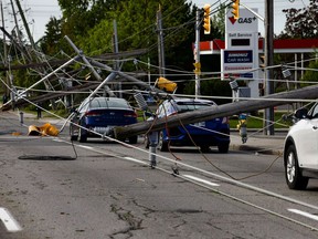
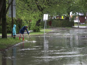
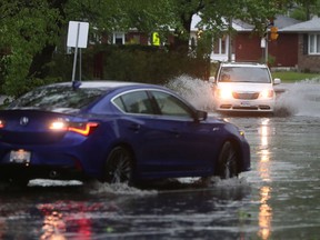
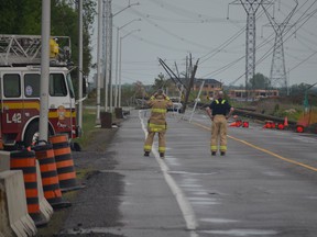
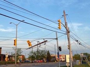
Merivale Road near Viewmount drive. Cars are trapped under wires with many down poles. Merivale Road is also closed in this area. Photo by Ashley Fraser /jpg
-

The scene from Merivale Road at Viewmount Drive on Sunday, May 22, 2022. Cars are trapped under wires with many downed hydro poles. Merivale Road is closed in the area. Photo by Ashley Fraser /Postmedia
-
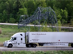
Major hydro lines were down along 417 at Hunt Club on May 22, 2022 Photo by ASHLEY FRASER /Postmedia
-

Aftermath of storm, May 22, 2022 The Esso station at Hunt Club and Conroy roads was open on Sunday morning, May 22, 2022. There were lineups with people filling containers with gas. Photo by ASHLEY FRASER /Postmedia
-

Aftermath of storm, May 22, 2022 The Esso station at Hunt Club and Conroy roads was open on Sunday morning, May 22, 2022. There were lineups with people filling containers with gas. Photo by ASHLEY FRASER /Postmedia
-

Aftermath of storm, May 22, 2022 Hawthorne road was closed due to downed power lines on Sunday morning, May 22, 2022 Photo by ASHLEY FRASER /Postmedia
-
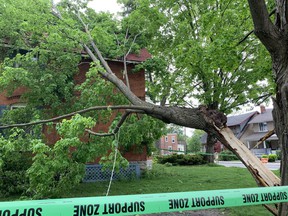
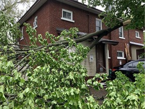
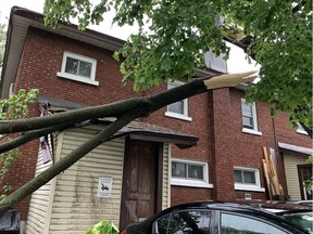
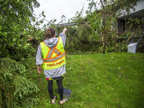
A tree branch fell on the roof of a house on Belmont Avenue. Owner Hendrik Woods said there doesn’t appear to be major structural damage. He was sitting in the yard with his phone, waiting on hold to report it to the city. Photo by Jacquie /Postmedia
-
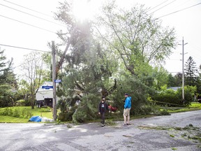
A powerful storm rolled through Ottawa Saturday, downing trees and flooding streets. Photo by Tony Caldwell /Postmedia
-
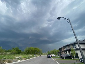
Storm clouds roll over Ottawa’s west end before the heavy thunderstorm hit the region on Saturday afternoon. Photo by Ashley Fraser /Postmedia
-
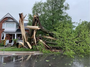
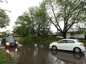
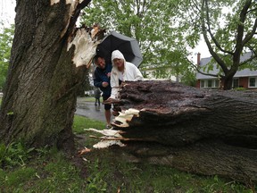
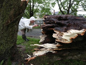
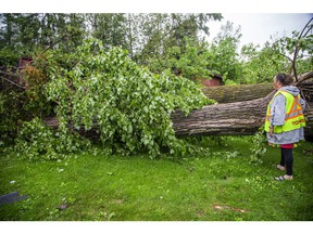
A huge tree came down in the storm on Saturday afternoon in the front yard of a house on Belmont Avenue near Bellwood Avenue in Old Ottawa South. Photo by Jacquie Miller /Postmedia
-
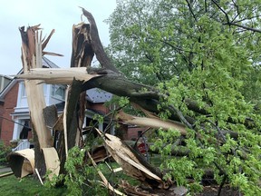
A huge tree came down in the storm on Saturday afternoon in the front yard of a house on Belmont Avenue near Bellwood Avenue in Old Ottawa South. Photo by Jacquie Miller /Postmedia
-
A powerful storm rolled through Ottawa Saturday, downing trees and flooding streets. Photo by Tony Caldwell /Postmedia
-
A powerful storm rolled through Ottawa Saturday, downing trees and flooding streets. Photo by Tony Caldwell /Postmedia
-
A tree branch fell on the back shed roof of a house on Cameron Avenue in Old Ottawa South during the storm Saturday afternoon. Photo by Jacquie Miller /Postmedia
-
A tree branch fell on the back shed roof of a house on Cameron Avenue in Old Ottawa South during the storm Saturday afternoon. Photo by Jacquie Miller /Postmedia
-
A powerful storm rolled through Ottawa Saturday, downing trees and flooding streets. Cleaning up on Smyth Road. Photo by Tony Caldwell /Postmedia
-
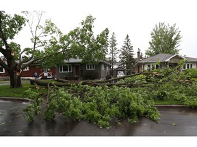
A powerful storm rolled through Ottawa Saturday, downing trees and flooding streets. Photo by Tony Caldwell /Postmedia
-
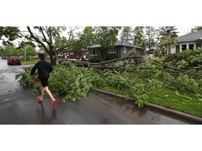
A powerful storm rolled through Ottawa Saturday, downing trees and flooding streets. Photo by Tony Caldwell /Postmedia
-
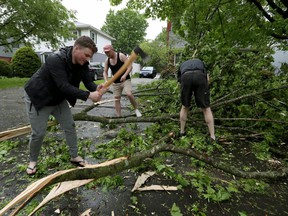
A powerful storm rolled through Ottawa Saturday, downing trees and flooding streets. Neighbours cleaning up on Weston Avenue in Ottawa. Photo by Tony Caldwell /Postmedia
-
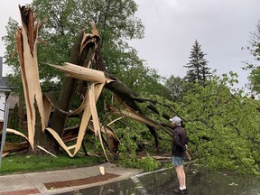
A powerful storm rolled through Ottawa Saturday, downing trees and flooding streets. John Tkaczewski and Agata Hawrylak look at a fallen tree on Weston Drive. Photo by Tony Caldwell /Postmedia
-
A powerful storm rolled through Ottawa Saturday, downing trees and flooding streets. Agata Hawrylak took a photo of a fallen tree on Weston Drive after the storm. Photo by Tony Caldwell /Postmedia
-
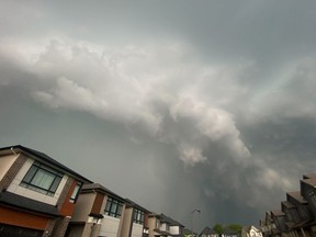
Storm clouds roll over Ottawa’s west end before the heavy thunderstorm hit the region on Saturday afternoon. Photo by Ashley Fraser /Postmedia
-

Storm clouds roll over Ottawa’s west end before the heavy thunderstorm hit the region on Saturday afternoon. Photo by Ashley Fraser /Postmedia
-
A huge tree came down in the storm on Saturday afternoon in the front yard of a house on Belmont Avenue near Bellwood Avenue in Old Ottawa South. Photo by Jacquie Miller /Postmedia
-
Downed hydro lines closed Shea Road in Stittsville after Saturday afternoon’s wild storm. Photo by Blair Crawford /Postmedia
-
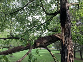
A tree appears to have been scorched by lightning in Windsor Park on Saturday, May 21, 2022. Photo by Jacquie Miller /Postmedia
-
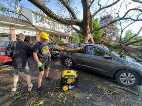
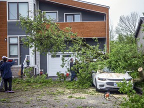
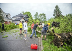
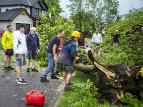
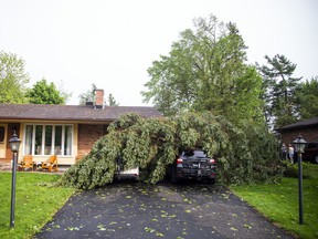
Paul McMahon (in a yellow hard hat) and his son Matt work to remove the enormous tree that crushed their new Honda in the driveway of their lizard Street home. Photo by Blair Crawford /Postmedia
-
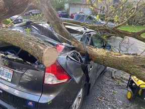
Paul McMahon and his son Matt had to work to remove the enormous tree that crushed their new Honda in the driveway of their Lizard Street home. Photo by Blair Crawford /Postmedia
-

Ottawa Fire Services had Stittsville Main Street closed off Saturday due to downed hydro lines fallen trees. Photo by Ashley Fraser /Postmedia
-

Ottawa fire had Stittsville Main Street closed off due to downed hydro lines fallen trees. Photo by Ashley Fraser /Postmedia
-
The Stittsville area and many other parts of the Ottawa region were hit hard by a powerful storm on Saturday, May 21, 2022. People in the area off Stittsville’s Main Street worked hard as a community to quickly clear streets and clean up fallen trees. Photo by Ashley Fraser /Postmedia
-
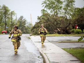
The Stittsville area and many other parts of the Ottawa region were hit by a powerful storm on Saturday, May 21, 2022. Firefighters run up Carleton Cathcart Street. Photo by Ashley Fraser /Postmedia
-
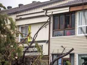
The Stittsville area and many other parts of the Ottawa region were hit by a powerful storm on Saturday, May 21, 2022. A person peers out the window looking at the large amount of damage at a residence on Carleton Cathcart Street. Photo by Ashley Fraser /Postmedia
-
The Stittsville area and many other parts of the Ottawa region were hit by a powerful storm on Saturday, May 21, 2022. A person peers out the window looking at the large amount of damage at a residence on Carleton Cathcart Street. Photo by Ashley Fraser /Postmedia
-
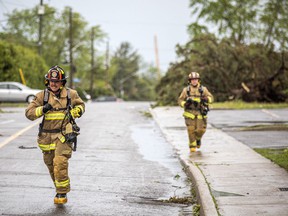
The Stittsville area and many other parts of the Ottawa region were hit by a powerful storm on Saturday, May 21, 2022. Firefighters run up Carleton Cathcart Street. Photo by Ashley Fraser /Postmedia
-
The Stittsville area and many other parts of the Ottawa region were hit by a powerful storm on Saturday, May 21, 2022. A woman assesses the damage in her front yard at a home on Stittsville Main Street. Photo by Ashley Fraser /Postmedia
-
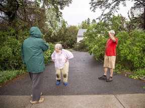
The Stittsville area and many other parts of the Ottawa region were hit by a powerful storm on Saturday, May 21, 2022. A woman assesses the damage in her front yard at a home on Stittsville Main Street. Photo by Ashley Fraser /Postmedia
-
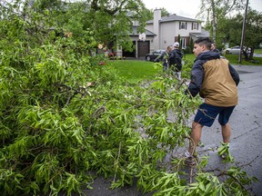
The Stittsville area and many other parts of the Ottawa region were hit by a powerful storm on Saturday, May 21, 2022. People in the area off Stittsville Main Street worked hard as a community to quickly clear streets and clean up fallen trees. Photo by Ashley Fraser /Postmedia
-

The Stittsville area and many other parts of the Ottawa region were hit by a powerful storm on Saturday, May 21, 2022. Photo by Ashley Fraser /Postmedia
-
The Stittsville area and many other parts of the Ottawa region were hit by a powerful storm on Saturday, May 21, 2022. A large amount of damage at a residence on Carleton Cathcart Street. Photo by Ashley Fraser /Postmedia
-
The Stittsville area and many other parts of the Ottawa region were hit by a powerful storm on Saturday, May 21, 2022. People in the area off Stittsville Main Street worked hard as a community to quickly clear streets and clean up fallen trees. Photo by Ashley Fraser /Postmedia
-
The Stittsville area and many other parts of the Ottawa region were hit by a powerful storm on Saturday, May 21, 2022. People in the area off Stittsville Main Street worked hard as a community to quickly clear streets and clean up fallen trees. Photo by Ashley Fraser /Postmedia
-
The Stittsville area and many other parts of the Ottawa region were hit by a powerful storm on Saturday, May 21, 2022. Photo by Ashley Fraser /Postmedia
-
The Stittsville area and many other parts of the Ottawa region were hit by a powerful storm on Saturday, May 21, 2022. Photo by Ashley Fraser /Postmedia
-
The Stittsville area and many other parts of the Ottawa region were hit by a powerful storm on Saturday, May 21, 2022. Photo by Ashley Fraser /Postmedia
-
The Stittsville area and many other parts of the Ottawa region were hit by a powerful storm on Saturday, May 21, 2022. Photo by Ashley Fraser /Postmedia
-
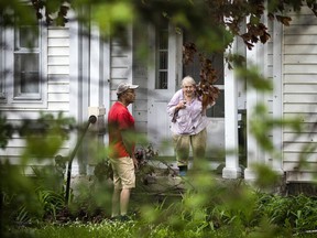
The Stittsville area and many other parts of the Ottawa region were hit by a powerful storm on Saturday, May 21, 2022. Karrie Phythian showed off the damage to one of her neighbours homes on Henry Goulburn Way Photo by Ashley Fraser /Postmedia
-
The Stittsville area and many other parts of the Ottawa region were hit by a powerful storm on Saturday, May 21, 2022. Karrie Phythian showed off the damage to one of her neighbours homes on Henry Goulburn Way Saturday evening. Photo by Ashley Fraser /Postmedia
-
The Stittsville area and many other parts of the Ottawa region were hit by a powerful storm on Saturday, May 21, 2022. People in the area off Stittsville Main Street worked hard as a community to quickly clear streets and clean up fallen trees. Photo by Ashley Fraser /Postmedia
-
The Stittsville area and many other parts of the Ottawa region were hit by a powerful storm on Saturday, May 21, 2022. People in the area off Stittsville Main Street worked hard as a community to quickly clear streets and clean up fallen trees. Photo by Ashley Fraser /Postmedia
-
The Stittsville area and many other parts of the Ottawa region were hit hard by a powerful storm on Saturday, May 21, 2022. People in the area off Stittsville’s Main Street worked hard as a community to quickly clear streets and clean up fallen trees. Photo by Ashley Fraser /Postmedia
-
The Stittsville area and many other parts of the Ottawa region were hit by a powerful storm on Saturday, May 21, 2022. Photo by Ashley Fraser /Postmedia
-
The Stittsville area and many other parts of the Ottawa region were hit by a powerful storm on Saturday, May 21, 2022. Photo by Ashley Fraser /Postmedia
-
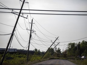
The Stittsville area and many other parts of the Ottawa region were hit by a powerful storm on Saturday, May 21, 2022.Fallen lines were seen along Shea Road Saturday. Photo by Ashley Fraser /Postmedia
-
The Stittsville area and many other parts of the Ottawa region were hit by a powerful storm on Saturday, May 21, 2022. Photo by Ashley Fraser /Postmedia
-
A powerful storm rolled through Ottawa Saturday, downing trees and flooding streets. Photo by Tony Caldwell /Postmedia
-
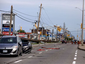
Storm damage along Merivale Road on Saturday, May 21, 2022. Photo by Jiaren Suo /Supplied
-
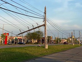
Storm damage along Merivale Road on Saturday, May 21, 2022. Photo by Jiaren Suo /Supplied
-

Storm damage along Merivale Road on Saturday, May 21, 2022. Photo by Jiaren Suo /Supplied
All 61 Photos for Gallery
Function Not Available
Full Screen is not supported on this browser version.
You may use a different browser or device to view this in full screen.
3
This storm formed over Southwestern Ontario Saturday morning as cold air blew in from Michigan. It raced east across the countryside, hitting Ottawa in mid-afternoon without much warning. Its arrival was “a very sudden kind of change with lots of strong gusts,” Phillips said.
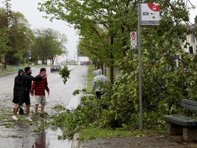
People were outdoors golfing, boating and preparing for barbecues, and some didn’t have the chance to reach shelter. Three people died in the Ottawa-Gatineau and Renfrew regions and more than 170,000 customers were still without power as of early Sunday afternoon, according to Hydro Ottawa.
Ottawa’s biggest gust reached 120 kilometres per hour Saturday, and Quebec recorded one of 145 km/h, both of which Phillips called “hurricane-force gusts,” though a true hurricane has sustained wind speeds.
4
Then around 4 p.m., as the storm blew through, the temperature dropped to 17.5 C and the humidity fell by nearly half, as cooler air pushed in from the west
Phillips said this was different from a storm system that breeds tornados.
“What we see here is a downburst wind,” very high in energy, but travelling in a straight line rather than spinning like a tornado, he said.
One striking aspect was how the storm formed a long line that raced across Ontario from west to east, he said.
“It’s almost like a family of tornados, or a line of microbursts, like soldiers on the front line all moving in the same direction and mowing down everything in its path.”
Such a storm is sometimes called a “derecho,” he said — a storm across a broad area moving for a long distance, with winds all in a straight line, not rotating.
5
Phillips later traced the path of the storm and was surprised by its speed: from London around noon, to Toronto at 1 p.m., Kingston by 3 p.m. and Ottawa by 4 p.m., “almost as if it was scripted.
“You couldn’t travel up the (Highway) 401 faster than this system.”
“And it brought the same kinds of weather to all those sites,” all the way to Quebec City, including “toonie-sized hail.
“The damage is very tornado-like.
“It was helped along by that undercutting cold front that pushes that warm, humid air up, and then the rain kind of cools it coming down. It’s almost as if mankind couldn’t produce a more violent kind of system than what we saw.”
-

Ottawa communities assess storm damage, few short years after tornados
-
Powerful storm leaves trail of death and destruction in capital region


6

Reference-ottawacitizen.com