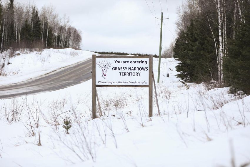
In deciding to approve a series of mining permits in the northwestern corner of the province, the Ontario government turned to a more than 30-year-old map of the Grassy Narrows First Nation.
Exploratory drilling would occur beyond the First Nation strip, according to the map. So, the government decided, there was no need to consult the nearby indigenous community.
The government was knowingly using an outdated and inaccurate map, members of the First Nation office, drilling and green-lit excavations in areas where residents say they are going to hunt elk, gather berries and camp.
“Grassy Narrows has been very clear for many years about the area that we use and want to protect. The only reason I can see to use a different map is deception and bad faith, ”said Grassy Narrows spokesman JB Fobister.
The First Nation says it has provided the government with an updated map of the area, what is now called Indigenous Sovereignty and Protected Area, several times over the past decade.
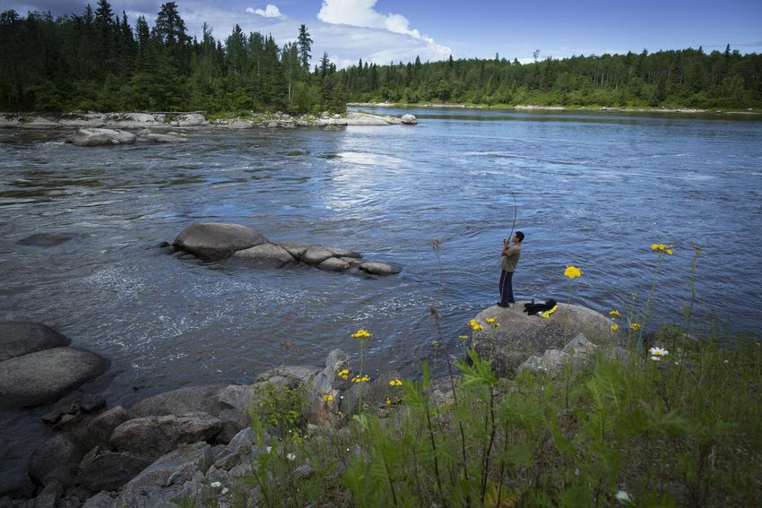
For the Grassy Narrows, where generations of residents have suffered mercury poisoning after a pulp mill dumped its industrial waste into the river, mining permits pose another threat to their community.
“Our land and our way of life are already at breaking point due to the continued impacts of residential schools, hydroelectric dams, mercury poisoning and the felling of felled trees,” said Fobister.
Mining, he added, “would further fragment and degrade” the environment.
Drew Campbell, a spokesman for the Ministry of Northern Development, Mines, Natural Resources and Forestry, wrote in an email that Ontario is committed to fulfilling the Crown’s duty to “consult with indigenous communities and strive to strengthen relationships with these communities. “
Campbell said the government is “reviewing the circumstances in which these permits were issued” and that the ministry is willing to meet with members of the Grassy Narrows “to discuss and resolve these issues.”
Grassy Narrows officials say they were not informed about the exploration permits before they were issued between August 2019 and February 2021. They only found the active permits in April.
The eight permits collectively cover more than 42,000 acres, about a third of which are within the Grassy Narrows area, according to the First Nation.
Under the Ontario Mining Act, the government has a duty to consult indigenous communities potentially affected by mining activities before deciding whether to issue a permit.
The ministry spokesperson said the province consults with indigenous communities on mining exploration applications when they understand that the activities of the proposed project have the potential to “negatively affect the rights of Aboriginal people and / or treaties established or credibly affirmed. of a community “.
The ministry did not notify Grassy Narrows of the eight mining permits because they “lie outside” what the government understood at the time was traditional First Nation land, a spokesperson said.
“Over time, (Grassy Narrows) has asserted jurisdiction over a significantly larger area of Crown provincial land than what community members had previously identified as the community’s traditional land use area,” Campbell said. .
Grassy Narrows officials told Torstar that the old map was hastily made in the 1980s and was not accurate. They say it was replaced a decade ago.
As early as 2011, the First Nation presented an updated map of the Grassy Narrows during a court battle to determine whether the government had the power to authorize logging in the area.
Over the past decade, Grassy Narrows says it has submitted the same updated map to the Ontario government multiple times. In 2017, the updated area map was included in the province’s 10-year management plan for logging part of the Whiskey Jack forest, home to the Grassy Narrows and where clearcut logging was suspended.
The area of the new map was not questioned by the government, according to Grassy officials.
Grassy Narrows has also requested that the land outlined on the map be designated by the federal government as an Indigenous Protected and Conserved Area (IPCA).
IPCAs are lands and waters where indigenous governments assume a leading role in the protection and conservation of an ecosystem. That role includes determining land boundaries and management plans. No decision has been made on the appointment.
Campbell said in September 2018 that the ministry contacted Grassy Narrows about an additional permit application, not one of eight permits covering 42,000 acres, that overlapped the Grassy Narrows territory based on the map above. He said there was no response.
Fobister said Grassy officials never received correspondence about the application.
The ministry approved that permit in 2019.
“In general, it is not honorable to send a letter to a community in crisis and then saddle up with potentially harmful industrial activities if no response is received,” said Fobister.
Grassy Narrows officials say they requested resolution of disputes under the Mining Act in response to an email from ministry staff inviting discussions on the indigenous protected area map.
The invitation came on June 25, more than a year after the first of the eight permits was approved, and after the indigenous community repeatedly wrote to the ministry for information on the permits.
Minister Greg Rickford agreed to meet with Grassy Narrows officials to discuss dispute resolution and the first exploration permits in question.
Ontario approved these exploration permits at a time when the Grassy Narrows saw an increase in active mining claims.
An April 2021 Torstar investigation found that the area covered by mineral claims had quadrupled in the Grassy Narrows territory since October 2018, when the First Nation made a land declaration prohibiting industrial activities, including mining. exploitation of minerals and mining, in its territory.
The Doug Ford administration was criticized for facilitating mining in the territory while alleged mercury dumps upstream have not been excavated.
A ministry spokesperson had attributed the rise in gold claims to rising mineral prices, as well as the discovery of gold on a nearby property in 2018. He also noted that the overwhelming majority of claims registrations and mining projects exploration does not result in an operating mine.
Toronto Star investigations have previously identified two suspected mercury dump sites upstream from the Indian community, where residents have long suffered physical and mental health problems due to mercury poisoning.
Fish near the Grassy Narrows remain the most contaminated in the province, and scientists strongly suspect that old mercury still contaminates the mill site and pollutes the river.
The spokesperson said the ministry holds the plant site owner Domtar responsible for assessing the extent of mercury contamination at and around the site.
JOIN THE CONVERSATION
Reference-www.thestar.com