
Parts of British Columbia are likely to enter “uncharted territory” with drought if they experience another hot, dry summer, says the director of the province’s River Forecast Centre.
Dave Campbell says persistent drought conditions in British Columbia date back to 2022, so the province is heading into this summer with “multi-year” precipitation deficits.
Satellite photos show rivers across the province are narrower and shallower than at the same time in 2023, which happened to be one of the driest years on record in British Columbia.
With average snowpack levels lower than those recorded in British Columbia last winter, Campbell says he expects cumulative effects that could include water shortages and other challenges.
“We know that these antecedent conditions that we face this year are much more challenging than what we started last year,” he said in a recent interview.
“The concern obviously is if we have that prolonged hot and dry (period) that we’ve seen last year and also the year before. If that continues this summer, then we’re really on the path to things we haven’t seen.” seen in recent memory.”
The Interior pockets are especially dry. Campbell said he is most concerned about the effects of the drought on smaller rivers and streams in the central interior.
“Prince George, Quesnel, Williams Lake, Vanderhoof, that’s the hotspot, and then the other (area) that would be concerning would be in the northeast,” he said.
The area around Vanderhoof, British Columbia, west of Prince George, has seen about 220 millimeters of rain over the past year, when it normally falls about 460 millimeters, he said.
#Rivers recede as #BC faces the prospect of ‘uncharted territory’ for #drought. #Climate Crisis #Summer #LowWaterLevels
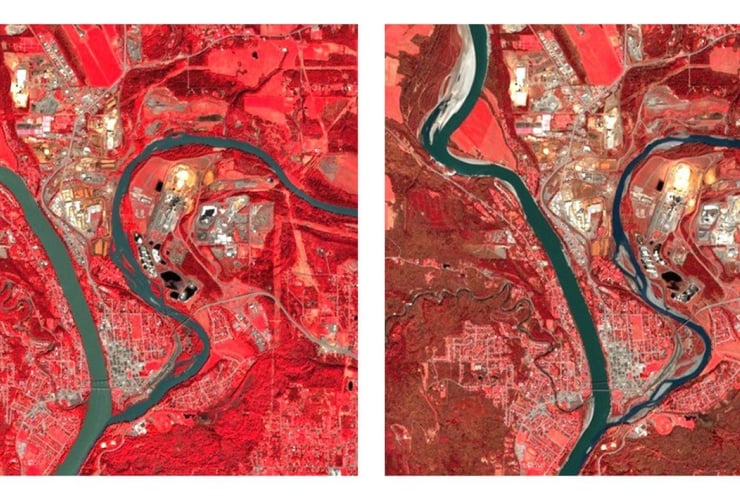
Images provided by the Canadian Space Agency appear to show the effects of the persistent drought in the Interior compared to those taken last spring.
An image taken last week by the The European Space Agency’s Sentinel-2 satellite shows the Quesnel River is narrower, with more banks exposed this month compared to an image taken a year ago. Last week’s photograph shows patches of exposed riverbed and sandbars, indicating lower water levels in the tributary as it meets the upper Fraser River at Quesnel.
Satellite images tell a similar story in Fort St. James, BC, where the water appears shallower this year as Lake Stuart empties into the Stuart River.
The Fort Nelson and Muskwa rivers also appear narrower, with more banks exposed compared to images taken in April 2023.
The Canadian Space Agency notes that the images use infrared “false colours” because they show the boundaries between land and water more clearly than other representations.
Campbell said parts of British Columbia’s Okanagan will also likely see the effects of the moisture deficit and low amounts of snow that melted earlier this spring.
Meanwhile, on northern Vancouver Island, he said, the community of Port Hardy, British Columbia, has seen 1,260 millimeters of rain over the past year, when it normally receives a little more than 1,800 millimeters.
“A few months of rain during the wet season” would be needed to alleviate the drought, he said.
BC’s snow study last month found snowpack across the province was “extremely low,” averaging 63 per cent of normal. The Quesnel area was listed at 52 percent of normal, while the neighboring West-Road Chilcotin region was at zero percent.
Officials are expected to hold a news conference on the drought and wildfires on Thursday when the province releases its latest snowpack bulletin.
This report by The Canadian Press was first published May 9, 2024.