Authorities in Manitoba now say a flood the size of 2009 is possible for the Red River Valley.
Fisaha Unduche of Manitoba Transportation and Infrastructure provided an update Friday afternoon on the current and projected flooding situation in our province. Unduche says the new projections are a result of the two Colorado lows that have hit our region in recent weeks, in addition to the Colorado low expected this weekend.
According to Unduche, Manitoba’s southern basins could get 30 to 80 millimeters of rain this weekend, while Fargo could get up to 90 millimeters.
“Because of this, we have just issued a flood watch for most of the southern Manitoba watersheds,” he adds.
Unduche says that between April 1 and 28, the Manitoba basins received between 40 and 140 millimeters of precipitation. That puts southern Manitoba between 200 and 500 percent of normal. He notes that a normal amount of precipitation for that time period is 28 millimeters, while the basin average was 80 millimeters. Unduche says April precipitation so far this year is the highest since 1950. On top of that, the chance of getting as much rain in April as Winnipeg last weekend is one in 87 years.
The province now expects the Red River to peak in Emerson between May 7-9 and at the entrance of the floodway around May 14.
Meanwhile, Transport and Infrastructure Minister Doyle Piwniuk says that as of Friday afternoon, six Manitoba municipalities have declared a local state of emergency. However, he points out that because so many homes and communities have ring levees, most of the evacuations that will take place will not be due to flooded basements, but due to loss of road access. Piwniuk says that anyone who needs assistance during the flood should contact their rural municipality.
Piwniuk says there’s a chance they could set up a bypass, starting Friday night, for traffic that wants to head south on Highway 75 toward Morris. The bypass will take motorists along Provincial Route 246. He notes that the south levee in Morris will remain open for the time being, though he anticipates that it will also likely close at some point in the next few days.
Below is the full Flood Bulletin issued by the province on Friday afternoon:
The Manitoba Transportation and Infrastructure Hydrological Forecast Center is monitoring a rainfall system forecast for this weekend that is expected to bring 1-3 inches of rain to the southern and central Manitoba watersheds, including U.S. portions. of the Red and Souris river basins. This is a dynamic system and precipitation amounts and locations could change as the system moves toward Manitoba.
The Hydrologic Forecast Center is closely monitoring this system and its impacts on Manitoba’s river flows and levels. Depending on the amount of precipitation received, levels along the Red River between Emerson and the floodway entrance could be similar to those seen in the spring 2009 floods. Forecasters will continue to monitor the system and post updates as that more information is known.
Flood watches have been issued for parts of southern and central Manitoba due to the risk of inland flooding in these areas as a result of the forecast rainfall. Most of the ditches and watercourses are full or close to capacity. Heavy rains that occur over a short period of time on saturated soils could create surface flooding.
Water levels in the Red, Assiniboine and many other rivers are rising. The rate of rise in the Red River watershed and creeks in south central Manitoba has slowed compared to the rapid water level rise seen in many places earlier in the week. Rivers and tributaries in areas that still have snowpacks should expect rapid increases in water levels as runoff from melting snow increases. This weekend’s rainfall will cause further increases in the water level.
The Red River Floodway and Portage Bypass continue to operate to lower water levels in Winnipeg.
Provincial crews are deployed to various communities in the Red River Valley executing pumping operations, as well as preparing for and implementing levee closures as needed. Crews are closely monitoring river levels in the city of Morris and have been working to keep Provincial Trunk Highway (PTH) 75 open as long as possible. However, rising water levels mean PTH 75 north of Morris is expected to close later tonight. Traffic from PTH 75 will be diverted onto Provincial Road (PR) 205 in Aubigny, along PR 246 to PTH 23 in Morris, and back to PTH 75.
Rising waters may require levee or road closures in some locations, and Manitobans are reminded to stay away from closed roads and not attempt to travel through flooded roads. Up-to-date information on road conditions, including detours and road closures, is available at www.manitoba511.ca or by calling 511. Manitobans should also stay away from waterways, including creeks, creeks , rivers and floodways. High flows, debris, and low temperatures present a significant safety risk.
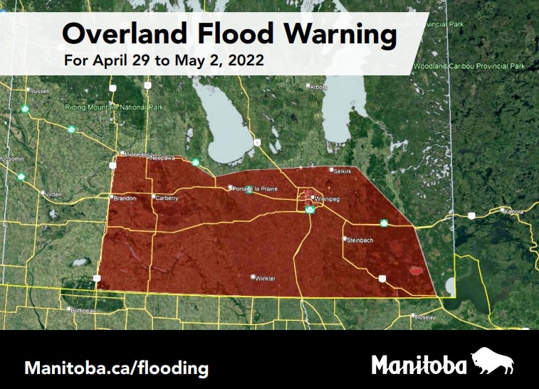 Flood forecasters have announced that the land-based flood warning has been expanded to cover more areas of southern Manitoba. Image courtesy of the Province of Manitoba.
High Water Level Warnings and Notices:
A flood warning is in effect for the Red River from Emerson to the entrance of the Red River Floodway and the La Salle River. A flood watch is issued for the Roseau River and a flood watch is maintained for all tributaries of the Red River.
A flood warning remains in place for the Pembina River in Manitoba. Forecasters continue to monitor weather and basin conditions and will update river forecasts to reflect conditions.
A flood warning has been issued for the Fisher River.
Water levels in the Assiniboine River are rising due to local runoff and tributary inflows. A flood warning remains in effect for the Assiniboine River from St. Lazare to Brandon. Shellmouth Dam is being operated to reduce the risk of downstream flooding on the Assiniboine River, while at the same time providing sufficient storage for the water supply.
A flood watch has been issued for the Whitemud River.
A high water advisory remains in effect for the Whiteshell Lakes area as levels in most lakes continue to rise due to recent rain and snowmelt.
Moderate flooding is expected for the Souris River between the US-Canada border to Wawanesa. There is a risk of moderate flooding in the eastern region, including the Roseau and Rat Rivers and the Whiteshell Lakes area. Water levels are generally stable or rising in streams and tributaries. There is a risk of moderate flooding within the Interlake region depending on how the rainfall system impacts the area and how fast the snow melts. There is a low risk of spring flooding in the northern Manitoba watersheds, including the Saskatchewan and Carrot River watersheds. Most of Manitoba’s major lakes are expected to remain within their desirable levels after spring runoff.
Flood forecasters will continue to monitor precipitation amounts and assess impacts on flows and levels. The latest river forecast information can be found at www.gov.mb.ca/mit/floodinfo/index.html.
The Manitoba Emergency Measures Organization continues to work with all local authorities and emergency management partners to provide guidance and support for preparedness and response activities.
Private well owners are reminded to test their wells to determine if they need to take steps to improve water quality and address potentially harmful bacteria. Testing at least once a year is recommended, especially after spring runoff or in the event of land-based flooding.
For more details on well water testing, visit www.gov.mb.ca/sd/pubs/water/drinking_water/factsheet2_test_wellwater.pdf.
For more information on flooding in Manitoba, visit www.manitoba.ca/flood.
Reference-pembinavalleyonline.com