
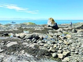
The rock most likely traveled, via a glacier, hundreds of kilometers from the Coastal Mountains north of Vancouver between 10,000 and 20,000 years ago.
.
VICTORIA — As Victoria’s coastline experiences some of its lowest tides in years, receding waters have exposed a slab of granite at Harling Point, the rocky beach next to the Chinese cemetery in Oak Bay.
Announcement 2
.
It’s no ordinary rock, according to Edwin Nissen, professor of ocean and earth sciences at the University of Victoria. It most likely traveled, via glacier, hundreds of kilometers from the Coast Mountains north of Vancouver between 10,000 and 20,000 years ago.
Nissen said the technical term is glacial erratic, basically a rock out of place, in this case an igneous rock from the continent that has been transported by glacial movement.
During the Pleistocene era, which ended about 12,000 years ago, huge glaciers descended from the coastal mountains, over Vancouver Island, and into the Pacific Ocean.
The steady flow of the glacier would have uprooted rocks and transported them in the ice, eventually depositing them randomly as the glacier melted, as the age of massive glaciers came to an end.
Announcement 3
.
Igneous rocks, formed from magma, aren’t usually found off the coast of Vancouver Island, Nissen said.
Here, there is volcanic rock formed at the bottom of the sea and softer metamorphic rocks formed from sediments, often closer to land.
The crystallized igneous rock is not the only reminder of the historic glaciers along the region’s coasts. Nissen points out that glacial striae—basically scratch marks left by hard igneous rock along softer bedrock—reveal the north-south flow of the ice.
“When you have hard rock scraping on soft rock, the hard rock will produce these very deep grooves in the softer bedrock,” he said. “It’s not necessarily low tide, you can actually see them at any time. But they could be more exposed at low tide.”
Announcement 4
.
The markings are clues to a bygone era, but relatively speaking, the geological wonder shows just a flicker in Earth’s timeline, Nissen said.
“Twenty thousand or 10,000 years ago, every time these glaciers flowed and receded, it was the blink of an eye in geological terms,” he said. “The earth is 4.5 billion years old and many of the rocks we see here are tens or hundreds of millions of years old.”
While visible at normal tides, the strange rocks and glacial striations are now revealed in full due to an abnormally low tide, a phenomenon caused by the high summer solstice sun aligning with the closest full moon in its orbit. orbit the Earth, also called the moon. in perigee.
The tide has receded 20 to 25 centimeters below the average low tide line, said Richard Dewey, associate director of science for Ocean Networks Canada. The last full moon in June brought similar low tides.
ad 5
.
“They are rare but not unexpected,” Dewey said. “They often come together at this time of year and particularly during the summer solstice.”
The phenomenon also creates a long tidal cycle, he said.
“We often think of high tide and low tide as being about six hours apart, but on Wednesday we had a very low tide in the middle of the morning and the high tides were at midnight.”
The next major low tide event is expected in mid-June 2026.
With the sun and moon wielding their full power over British Columbia’s southern coast, the usually underwater worlds of vegetation, shellfish, crabs, and other intertidal life are also exposed to the sun. The adaptive coastal habitat is diverse and abundant, ranging from exposure to submersion.
“This habitat that gets exposed at these really low tides is really not that far out of reach,” Dewey said. “It’s 30 or 40 meters offshore on a sloping beach… It’s there all the time, but we can see it in the air during these low tides.”
ad 6
.
Dewey said low tides are only a concern if they align with heat domes like the one that hit BC last summer and killed an estimated 1 billion intertidal animals in the Salish Sea.
“If we experience more heat domes, they will occur during the summer solstice, when we see the lowest tides,” Dewey said. “The combination of those is something to watch out for.”
Those who want to explore the erratic glaciers or see intertidal species at low tide should do so, but with caution, Dewey said.
“We want to be passive observers and not add additional stress to these systems that are experiencing these low tides,” he said. “The last thing they need is for us to go and annoy them even more.
“Look and explore, but try not to disturb.”