
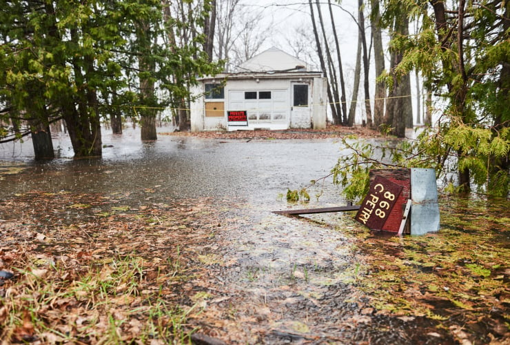
Along Canada’s coasts and coastlines, increased erosion, storm surges and rising sea levels are putting more homes at risk of flooding. However, an East Coast researcher has found that many people oppose flood risk mapping because they fear it will devalue their real estate.
That was the result of two surveys led by Kate Sherren, a professor at the School of Environmental and Resource Studies at Dalhousie University in Nova Scotia. Her findings were recently published in the research journal Canadian geographies. The first, conducted in 2021 in two cities in the province’s southwest, found that one in six people thought mapping would put real estate values at too great a risk. A 2022 survey, conducted in a coastal area near the Bay of Fundy, found that one in three residents had the same concern.
While those numbers reflect a minority opinion, Sherren said, “It doesn’t really matter how many… if those people have economic and political power.” And, more importantly, people and industries who reject similar measures can force governments to abandon them.
For example, Nova Scotia recently abandoned its Coastal Protection Act, which was to restrict where new houses and buildings could be built along the coast due to risks of erosion and flooding.
The survey results represent a widespread attitude among Canadian property owners and developers who feel threatened by flood mapping, Sherren explained. in a piece for The conversation, called public resistance to flood maps the “unacknowledged reason” Canada is so far behind in the practice. On the contrary, England has a country flood risk mapping systemwhere anyone can go online and search their area to see the risk of flooding.
In Canada, there are scattered flood maps in some places across the country, as municipalities and provinces move forward with their own mapping resources. In Nova Scotia, where four people died in historic flooding last summer, the province has said implement a flood mapping system by 2027.
Flood mapping is “an essential public good,” Sherren said, but generally, people with properties in flood-prone areas approach flood mapping from an individualistic perspective. The first survey found that the best predictor of people opposing flood maps was whether they believed their choice to live in a flood-prone area does not affect others.
It’s the wrong perspective, explains Ryan Ness of the Canadian Climate Institute, because there are broader impacts on communities when residential properties flood, as well as “more far-reaching financial impacts.”
“Because when people are affected by a flood, they look to the government to help them with disaster assistance, and that also comes from everyone’s taxes,” he said. “So it’s not just a matter of someone deciding to take the risk and accept it.”
At the same time, flood mapping protects people who might rent or buy a home in flood-prone areas. Communities should have access to this information so they can plan where to build, she added.
“Someone could, through no fault of their own, end up owning a flood-prone home that will not have flood insurance… and if it is affected by a flood and if the federal and provincial governments decide that it does not meet the criteria criteria disaster,” Ness said, “they could be affected by a destroyed house that is worthless.”
The issue of flood maps converges with concerns about insurance in flood-prone areas. Currently, insurance companies do not cover up to 10 per cent of homes in the event of flooding in Canada, a figure that will increase as climate change makes severe weather events more frequent. Quebec has the highest number of properties that are not eligible for flood insurance, followed by Ontario and British Columbia. Without insurance, residents cannot repair their homes if they are damaged or obtain mortgages in high-risk areas.
The federal government is currently developing a national flood insurance program. The 2021 budget allocated $31.7 million over three years for the creation of a low-cost flood insurance program to be developed by Public Safety Canada, Finance Canada and the Canada Mortgage and Housing Corporation.
Involve people
He explained that there were a couple of glimmers of hope in Sherren’s study. The first survey indicated that people who had previously seen a flood map for their region were less likely to object to the maps. In the second survey, people with children or grandchildren were less likely to oppose flood mapping.
“In many cases it is fear of the unknown. A lot of this is because people are really struggling to deal with change,” Sherren said.
Ultimately, people need to be convinced that flood mapping is in their best interest, which would require a big change in the way they view property and land ownership. The need for that change is increasingly urgent, Sherren explained, as flooding is Canada’s most costly hazard. Furthermore, people from all over the world are increasingly move to areas with high risk of flooding.
Flood mapping in Quebec
Quebec has also faced resistance to flood mapping, explained Catherine Perras of a non-profit organization. Vivre En Ville. Residents of the province are currently awaiting flood mapping, which was promised following flooding in the province in 2019 when more than 10,000 people were evacuated from their homes.
There is currently a wave of concern in Quebec after news that the Desjardin credit union will make it almost impossible to get a mortgage in the most flood-prone areas of the province. Perras says people fear the flood maps will lead to more rules and limitations, leaving them in the lurch with properties they can’t afford to protect.
Financial aid programs often intervene after major floods to help people fix their homes, if they can stay in the affected area. Perras wonders whether greater government support ahead of floods (for both renters and homeowners in flood-risk areas) would help allay fears around flood mapping.
“Why don’t we just have a prevention program, where we have the same thing, but before a flood if we are in a flood zone?” she said. “Perhaps if we focused on solutions at the same time as publishing these maps, they would be more accepted.”
— With files from Isaac Phan Nay