
They continue working on updating flood mapping studies that cover 1,600 kilometers of river channels in the province

Article content
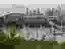
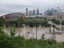
As the province braces for a severe drought, Alberta government officials continue to work on updating flood mapping studies covering 1,600 kilometers of waterways.
The province is currently seeking public comment on 27 flood studies across the province, covering 600 kilometers of updated mapping and 1,000 kilometers of new mapping.
Advertisement 2
Article content
Article content
“That’s more flood mapping we’re sharing with Albertans now than has been created in the last 35 years combined,” said Peter Onyshko, flood hazard specialist with Alberta Environment and Protected Areas.
The province accelerated flood mapping after the historic 2013 southern Alberta floods, the worst in Alberta’s history.
“We recognize that flood risks exist along Alberta’s rivers, and that flooding can cause property damage and hardship to people and, tragically, can also lead to loss of life, as occurred in 2013,” he said Onyshko.
Since 2015, the province has been working on new studies, which focus on water escaping a river’s banks and flooding a floodplain.
At the time, then-Alberta Auditor General Merwan Saher found that successive Conservative governments failed to put limits on development in flood-prone areas before the costly flood of 2013. The total cost of that flood has been estimated at $5 billion across southern Alberta, according to the City of Calgary.
Included in the updated mapping is 100-year flood risk, which municipalities typically use to make land-use decisions and plan future development around floodplains. The new flood maps show where areas could be flooded in floods of different sizes, from a small “minor” flood to an extreme but rare 1,000-year flood.
Midday news summary
Article content
Advertisement 3
Article content
“Our new flood studies provide more information about floods of different sizes than any previous size map,” Onyshko said.
Recommended by Editorial
-
‘Build it back better’: Return to High River, 10 years after the flood
-

Springbank Reservoir, the main legacy of the 2013 flood, moves forward
-

Solutions for Bow River flooding still uncertain: ‘Something catastrophic could happen’

The new maps are higher resolution, with more precise topographic data and updated hydrology, and were produced using modern engineering tools and processes, he said.
In the case of the town of Fort Macleod, through which the Oldman River flows, the new study began in 2019 and updates mapping completed more than 30 years ago, in 1991. The updated study incorporates an additional 40 years of flow into the new modeling. information along the Oldman River and Willow Creek. That includes five years in which Fort Macleod experienced flooding: 1986, 1991, 1995, 2005 and 2013.

Anthony Burdett, Fort Macleod’s chief administrative officer, said the updated mapping provides further support for the city’s position to deny certain development requests in the river valley.
Advertisement 4
Article content
“It helps us be proactive in the type of development we allow on our river valley lands,” he said.
The city is cautious about allowing housing construction in certain areas and does not allow housing construction on land zoned in the river valley, Burdett said.
The city tries to inform residents who live in the river valley that they are not allowed to build additions in those areas susceptible to flooding, where the city does not believe houses should have been built in the first place, he said.
If a 100-year flood occurs, Burdett estimated that residents living in eight residences would have to leave their homes.
The studies, including the Fort Macleod one, are being completed under the province’s Flood Hazard Identification Program, which aims to improve public safety and reduce future flood damage by identifying flood and river risks . The province has received funding through the National Disaster Mitigation Program for the studies.
TO total of 38 studies They are currently being worked on, with 11 more studies underway in addition to the 27 studies for which the province is seeking public comment by Feb. 12.
“We still have 600 kilometers of old maps that still need to be replaced and coverage expanded to even newer areas,” Onyshko said.
Article content