Related news
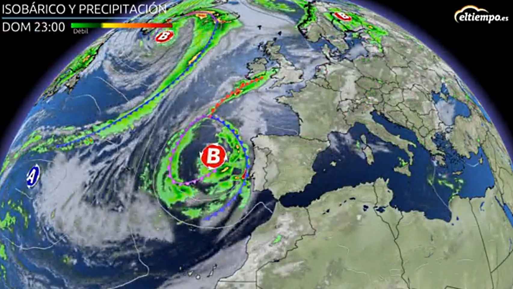
This weekend will be marked by stability and a warm environment, although this situation will change as of Monday due to the arrival of an Atlantic storm that will leave locally strong rains and showers throughout most of the country as well as a drop in temperatures, which will be “extraordinary” on Tuesday, with a drop in maximum temperatures of up to 10ºC., according to the spokesman for the State Meteorological Agency (AEMET) Rubén del Campo.
In any case, stable and dry weather will prevail over the weekend in much of the country, although there will be some rains in Galicia and the Cantabrian Sea and stormy showers in the northeast of the peninsula and the Balearic Islands. However, the approach of an Atlantic storm will lead to “a major weather shift” early next week, with an episode of rains between Monday and Wednesday that will affect most of the Peninsula and the Balearic Islands, except to the southeast coast.
It will be precipitation in the form of locally heavy showers accompanied by hail, especially at points in the western half of the peninsula and around the Pyrenees. Temperatures will also drop significantly, according to Del Campo.
On Sunday they will occur again showers in areas of the northeast of the peninsula and the Balearic Islands, which will be more likely in the mornings in coastal areas and in the interior in the afternoons, with the possibility of locally intense showers again. In the last hours, the The approach of the Atlantic storm will increase cloudiness in much of the western peninsula and could generate showers in the extreme west of Galicia.
Next week an Atlantic storm will visit us that will be leaving rains throughout the country since the beginning of the week. Tuesday could be the rainiest day and storms are also likely. The rains will be generalized and there will also be a thermal decrease⛈️☔️ pic.twitter.com/Mh8IZRw5Xp
– Eltiempo.es (@ElTiempoes) September 9, 2021
Regarding temperatures, They go up during the weekend so Del Campo has explained that there will be “a warm atmosphere for the time in a good part of the territory, especially on Sunday”.
Specifically, the highest temperatures will reach 34 degrees in the Guadalquivir Valley and some points in the interior of the Valencian Community and Region of Murcia, while the maximum temperature will be around 32 degrees in the Ebro, Tajo, Guadiana and Guadalquivir valleys. Meanwhile, in the Mediterranean area, tropical nights are expected, that is, those in which it does not drop below 20 degrees.
An “important” change is coming
As of Monday, the arrival of an Atlantic storm to the Peninsula, in combination with a bagging of cold air in the upper layers of the atmosphere, will give rise to “an important change of weather”, according to Del Campo.
Specifically, on Monday they expect locally strong showers accompanied by hail in Galicia, around the Central System, in Western Andalusia and the Pyrenees, showers that, throughout the day, will spread from west to east, although they may not reach the Mediterranean coast of the peninsula or the Balearic Islands.
The storm, in this first phase on Monday, will give rise to intense winds from the south, with very strong gusts in mountain areas and this wind from the south it will trigger the thermometers above 34 or 35 degrees in the eastern Cantabrian Sea, as well as in the Ebro Valley, points of Mallorca and also in the Guadalquivir Valley.
Tuesday, with the storm already over the Peninsula, will be a rainy day in practically the entire country, with generalized stormy showers, although regularly distributed locally strong and accompanied by hail. The most intense, in principle, will occur in Western Andalusia, Extremadura, points in the central area and around the Pyrenees and will be less likely on the southeast coast and in Menorca, although they also wait in the rest of the Balearic Islands.
On Wednesday, although atmospheric instability will continue, it will not be as pronounced as on the previous day, according to the spokesman, who has advanced that there may be showers in large areas of the Peninsula and the Balearic Islands, more frequent and intense in the north and less intense in the rest.
As for temperatures, they will drop in a notable and generalized way on Tuesday throughout the territory, except on the Mediterranean coast and in the Balearic Islands, where they will rise somewhat. In points of the peninsular center, the maximum temperature on Tuesday may be 10 degrees lower than that registered on Monday, so we can speak of “an extraordinary drop in temperatures”, in the words of the spokesperson.
For Wednesday the values will recover, except in the Cantabrian. These days the temperatures will be higher and will exceed 32 degrees, which will be recorded in areas close to the peninsular Mediterranean coast and in the Balearic Islands, which will be the hottest area due to the westerly winds that arrive there more reheated.
Follow the topics that interest you
Reference-www.elespanol.com