Authorities in Manitoba now say a flood the size of 2009 is possible for the Red River Valley.
Fisaha Unduche of Manitoba Transportation and Infrastructure provided an update Friday afternoon on the current and projected flooding situation in our province. Unduche says the new projections are a result of the two Colorado lows that have hit our region in recent weeks, in addition to the Colorado low expected this weekend.
According to Unduche, Manitoba’s southern basins could get 30 to 80 millimeters of rain this weekend, while Fargo could get up to 90 millimeters.
“Because of this, we have just issued a flood watch for most of the southern Manitoba watersheds,” he adds.
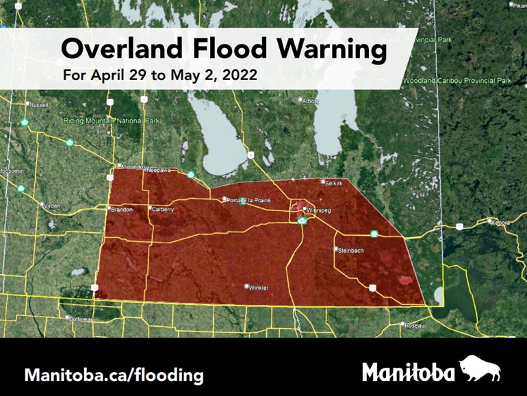 Flood forecasters have announced that the land-based flood warning has been expanded to cover more areas of southern Manitoba. Image courtesy of the Province of Manitoba.
A flood warning is in effect for the Red River from Emerson to the entrance of the Red River Floodway and the La Salle River. A flood watch has been issued for the Roseau River and a flood watch is in place for all tributaries of the Red River. A high water advisory is in place for the Whiteshell Lakes area as levels in most of the lakes they continue to increase due to recent rain and snowmelt.
Flood watches have been issued for parts of southern and central Manitoba due to the risk of inland flooding in these areas as a result of the forecast rainfall. Most of the ditches and watercourses are full or close to capacity. Heavy rains that occur over a short period of time on saturated soils could create surface flooding.
Water levels in the Red, Assiniboine and many other rivers are rising. The rate of rise in the Red River watershed and creeks in south central Manitoba has slowed compared to the rapid water level rise seen in many places earlier in the week. Rivers and tributaries in areas that still have snowpacks should expect rapid increases in water levels as runoff from melting snow increases. This weekend’s rainfall will cause further increases in the water level.
Unduche says that between April 1 and 28, the Manitoba basins received between 40 and 140 millimeters of precipitation. That puts southern Manitoba between 200 and 500 percent of normal. He notes that a normal amount of precipitation for that time period is 28 millimeters, while the basin average was 80 millimeters. Unduche says April precipitation so far this year is the highest since 1950. On top of that, the chance of getting as much rain in April as Winnipeg last weekend is one in 87 years.
The province now expects the Red River to peak in Emerson between May 7-9 and in Red River Floodway Inlet around May 14.
Meanwhile, Transport and Infrastructure Minister Doyle Piwniuk says that as of Friday afternoon, six Manitoba municipalities have declared a local state of emergency. However, he points out that because so many homes and communities have ring levees, most of the evacuations that will take place will not be due to flooded basements, but due to loss of road access. Piwniuk says that anyone who needs assistance during the flood should contact their rural municipality.
Piwniuk says there’s a chance they could set up a bypass, starting Friday night, for traffic that wants to head south on Highway 75 toward Morris. Traffic from Highway 75 will be diverted to PR 205 in Aubigny, along PR 246 to PTH 23 in Morris and back to Highway 75. He notes that the south levee in Morris will remain open for the time being, though he anticipates that it will probably also be closed. sometime in the next few days.
Reference-steinbachonline.com