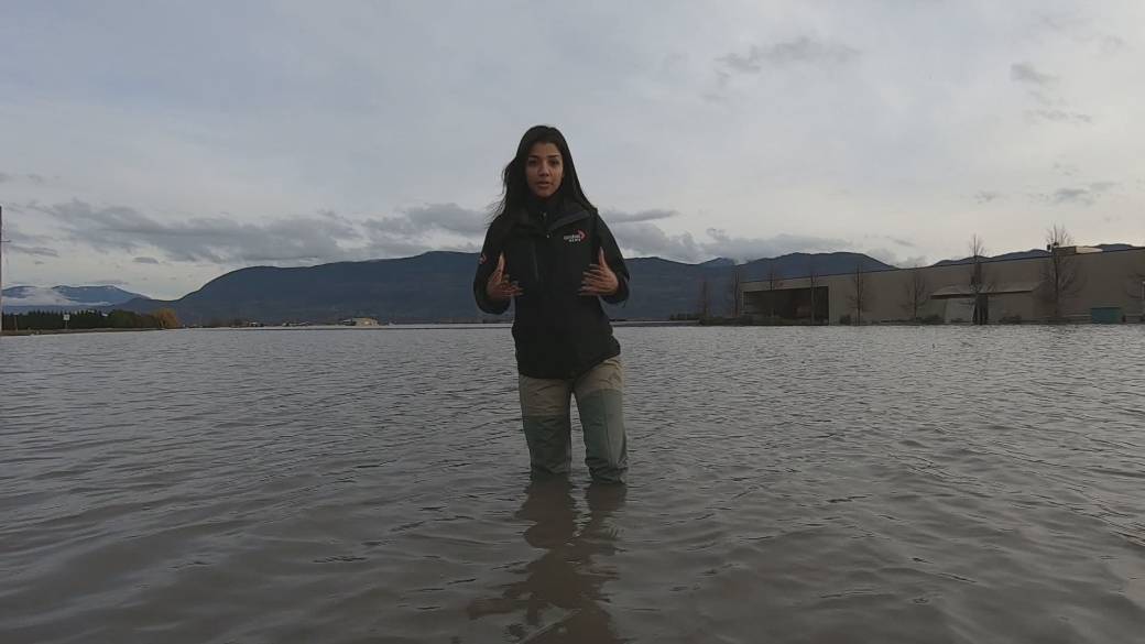
Southern British Columbia remained on “red alert” on Saturday, as the first of consecutive storms began to drench the part of the province already weary from flooding.
![]()
Environment Canada’s rain advisories remained in effect for Metro Vancouver, Fraser Valley, Howe Sound, the Sea to Sky region, and the Sunshine Coast.
Read more:
Environment Canada Issues First ‘Red Level Alert’ Ahead of Back-to-Back Storms in British Columbia
Rainfall amounts were forecast ranging from 60mm in Vancouver to 80mm in the Fraser Valley and up to 120mm around Squamish and near the mountains.
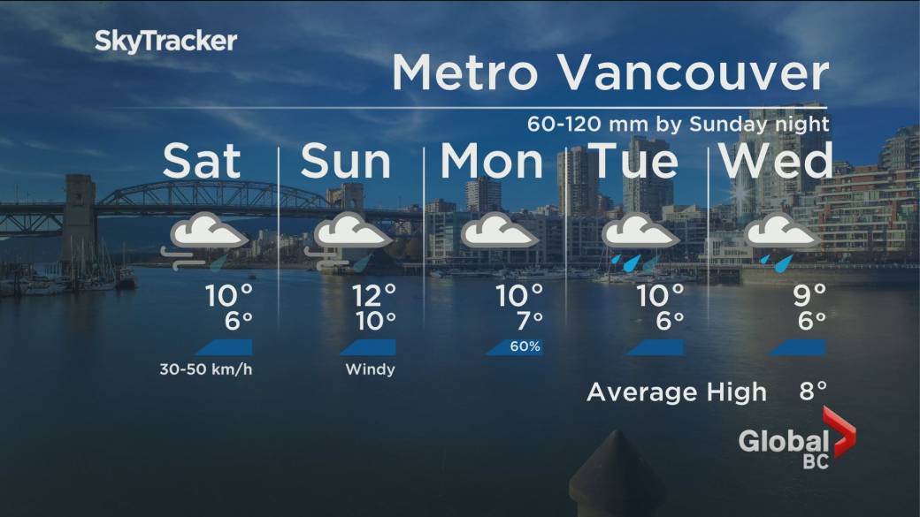
“Strong warming will accompany this system, causing freezing levels to rise well above the mountain tops today. Thaw will contribute to runoff, increasing the risk of flooding and possibly impacting vulnerable landscapes and infrastructure, ”said Environment Canada.
Abbotsford Sumas region still plagued by floods stayed under a flood warning, with Washington’s Nooksack River state at risk of breaking again Sunday, while the entire southern coast remains under flood watch.
The BC River Forecast Center also issued a flood watch for Vancouver Island, with the exception of the northern region which was under a high flow warning – as well as the Tulameen, Similkameen, Coldwater and Nicola rivers in the Interior of BC.


East, west and north Vancouver Island also faced rain warnings, while Fraser Canyon, Coquihalla between Hope and Merritt, and Highway 3 from Hope to Princeton also faced heavy rain warning weather statements.
Highway 1 through Fraser Canyon remained closed due to landslides, while the last two highways were closed as a precautionary measure on Saturday after suffering severe damage from the devastating atmospheric river on November 14.
The heaviest rain is forecast to fall on Saturday night, with precipitation expected to subside through Sunday afternoon.
Read more:
BC and Ottawa strike a new climate and disasters committee, pledge to match flood donations
Another storm is expected to hit the region on Wednesday and Thursday.
The storms, along with the already damaged and vulnerable nature of the landscape, prompted Environment Canada to issue its first “red level alert” on Friday.
The new classification system did not exist during British Columbia’s deadly heat wave or destructive wildfire season.
© 2021 Global News, a division of Corus Entertainment Inc.
Reference-globalnews.ca